
Participant Tracking using Challenge Maps
Using challenge race maps in addition to a standard leaderboard.
The standard leaderboard bar chart is a popular method for displaying participant standings. However, there are occasions when showing progress in the form of a race map is more effective at encouraging participation by adding realism and scale. For instance, an organization could run a virtual race between all their office locations. They would pick a location as their starting line and another as their finish line and then add all of the locations in between as waypoints. As participants accumulate points, their marker would move along the route until they reach the finish line. Along the way, they would be able to view other participant markers as well in order to judge progress and current challenge standings.
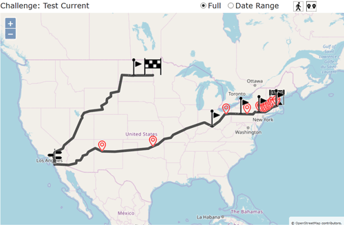
Starting line, Finish line, and Waypoints
In order to create a challenge map the admin must, at a minimum, supply a starting line and finish line. ChallengeRunner will accept an address (123 Freemont St, Las Vegas, NV) or just a general area (Dublin, Ireland) and will calculate an appropriate map location near the closest road. Once the system has more than one location, it will compute a route along available roads as well as the approximate distance from the starting line to the waypoint. If additional waypoints are added, the system will adjust the route as required.
Setting the Scale
When you create a challenge map, the default scale is 2000 points = 1 mile. This value approximates the number of steps walked per mile for the average participant (2000 steps = 1 mile). However, this ratio can be changed to whatever desired and can be used for any type of activity (not just walking or running). For instance, a hydration challenge where participants receive 1 point for every day they consume at least 64oz of water could be configured with a ratio to provide 1 or more miles per point. As users accumulate points, their marker moves across the map at the set scale. The unit of measure can be changed from miles to kilometers if needed.
Waypoints and Milestones
As mentioned above, admins can set the starting and ending destinations as well as waypoints along the route. In order to display accurate reporting on participant progress, we have integrated the Challenge Map and Milestone systems so that waypoint distance can easily be converted into milestones. Since the Milestone Report shows the time and date a checkpoint is crossed, admins and participants will know when each participant reaches a milestone and this further reinforces the "race" aspect of the challenge.